A Griffith University wetland ecologist has played a key role in new research that looked to the past to identify historical changes in mangrove and salt marsh dominance and distribution over the past 250 years.
The study of books, personal journals, scientific articles, logbooks, photos and maps found human-driven climate change would likely lead to dramatic changes in coastal ecosystems with mangroves expanding and persisting poleward of their current range limit.
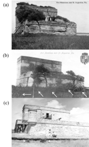
Fort Matanzas, Florida, taken in: (a) 1905-1908, (b) 1916-1927, and (c) 1964. Black mangroves are identified with white arrows on (b) and (c).
Alongside a US research team that included researchers from UCLA and The Smithsonian Institution, Dr Matthew Hayes from Griffith’s Australian Rivers Institute collected historical records from journals, photos, articles and maps to document how mangrove distribution along the Florida coastline had been highly variable in the past 250 years.
The research, published in PNAS, found that mangrove poleward expansion and the changes in community dominance from marsh to mangroves was the result of warmer periods, but the persistence of mangroves in more poleward locations was dependent on the frequency and intensity of extreme cold events.
In combining historical accounts of the Florida coastline area from historic books, personal journals, scientific articles, logbooks, photos and maps with historical climate data, the researchers showed that the ecotone – the transition area between two habitats – between mangroves and salt marsh had shifted dominance at least six times between the late 1700s and 2017.
Dr Hayes said this shift was due to the decadal-scale fluctuations in the frequency and intensity of extreme cold events.
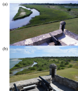
Southeast from Fort Matanzas, Florida, taken in: (a) 1969, and (b) 2018.
“It’s easy to think that because there’s a cyclical aspect throughout this 250 years of mangrove expansion and retreat that it’s business as usual, but it’s not just that mangroves can expand their range limit poleward, or that they shouldn’t be poleward of their current range limit,” he said.
“Our historical research tells us mangroves have temporarily expanded into regions poleward of their current range limit, but eventually extreme cold events have killed these poleward mangroves and pushed the range limit back toward the equator. However, climate change is now having these dramatic effects on our coastal ecosystems.
“Due to warmer winters, with reduced incidences of extremely cold weather events, mangroves are now able to expand away from the equator and persist into habitat poleward of their current range limit.
“Rather than being a temporary expansion into marsh habitat, warmer winters with less severe freeze events are allowing these shifts to be become permanent.
“This permanent shift from marsh to mangrove dominance can lead to dramatic changes in ecosystem structure and function as one habitat is replaced by another.
“For example, imagine a prairie grassland being replaced by a forest and the impact this would have on ecosystem services as well as plant and animal diversity.”
The research team incorporated their historical research into a model to project daily minimum temperatures from years 2000 to 2100 and found that annual minimum temperatures throughout this period will increase by 0.5C per decade.
Dr Hayes said this would significantly reduce the incidence of extreme cold events and allow a persistent state of mangrove dominance.
The research ‘Climate-driven regime shifts in a mangrove-salt marsh ecotone over the past 250 years’ has been published in PNAS.
Author